
|
Getting your Trinity Audio player ready…
|
Allston-Brighton residents can report flooding incidents through the City of Boston’s ongoing flood-survey research, which officials say will help determine future green infrastructure projects in the neighborhood.
The Community Based Flood Resilience and Green Infrastructure Survey has received nearly 200 responses in 12 months, Julie Wood, climate resilience director at the Charles River Watershed Association (CRWA), said in a presentation at the Green Infrastructure Planning & Flood Mapping Climate Social on February 3.
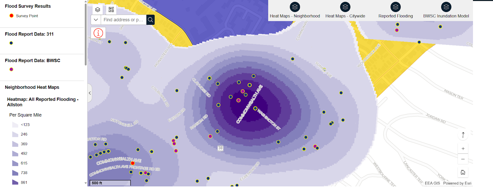
As part of the initiative, the City and its partners are building an interactive map for the public to see current and future flooding impacts in each neighborhood. Researchers will use existing data and community survey responses to identify flooding and combat water pollution in future projects.
Respondents reported that flooding caused longer commutes for drivers and pedestrians and caused property damage, Wood said.
One of three high-priority sites identified so far is Commonwealth Avenue, according to Max Rome, the City’s director of Green Infrastructure and an Allston resident. Flood map modeling shows major hotspots at intersections along Commonwealth Avenue, including Harvard Avenue and Washington Street.

Rome said when rain accumulates on impervious surfaces where water can’t be absorbed, the stormwater can carry pollutants into water bodies, like the Charles River or the harbor.
“I think in Boston we spend a lot of time thinking about the flooding threat from sea level rise,” Rome said. “But climate change is bringing more intense storms, and those intense storms are creating inland flooding that we’re already experiencing.”
The online mapping tool is part of a state-funded, two-year project, Community-Based Flood Resilience and Green Infrastructure Planning, that will include community input to target flood-prone areas and high-risk communities throughout the planning process.
Once the project is completed, the city and its partners will use the data to plan green infrastructure projects that can absorb rainwater and prevent flooding and runoff.
“We often focus on rain gardens, kind of small systems that can be fit into the city street, or they can be retrofitted from a parking lot,” Rome says.
“I think one thing that I do notice is just how narrow the streets are in Allston,” Juwaria Jama, an Allston resident since September, says. “Even right now, I’m noticing all the snow piling up […] where do you even put stuff like this? So I can imagine that when more rain starts in April, that there will be flooding.”
Joanna Argudo, CRWA’s climate resilience engagement associate, said the survey has already received reports from the melting snow.
However, Dira Johanif, the association’s senior climate resilience manager, finds that stormwater runoff presents a broader concern. Melting snow can carry trash and road salt into the river, contributing to pollution.
Jama, a community engagement coordinator with the Trustees of Reservations, said she attended the event to get a better scope of what different organizations are doing in the city.
Allston Brighton Health Collaborative (ABHC) is helping distribute the flood survey to community members, according to Jonathan Lee, the group’s transportation and mobility manager. Lee said he expects the coalition to take on a larger role as the project moves into its next phase.
Johanif said CRWA plans to continue community engagement efforts through walking tours and tabling events.
“The goal of any kind of engagement and projects we do on the ground is always [a] reflection of community needs,” Johanif said. “And if there is a project that’s ongoing and there’s an opportunity for us to partner and provide more content and expertise around green infrastructure or flood mitigation, that’s always something we’re open to doing.”
The flood survey team plans to host a public event to highlight its findings at the conclusion of the project in late June. ■
